
Make a donation
Gear up for your next adventure:
As an Amazon Associate, this site earns from qualifying purchases at no extra cost to you.
Nods topographic map
Click on the map to display elevation.
Make a donation
Gear up for your next adventure:
As an Amazon Associate, this site earns from qualifying purchases at no extra cost to you.
About this map
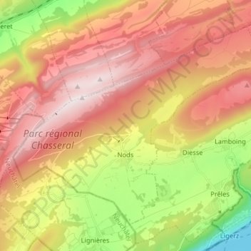
Name: Nods topographic map, elevation, terrain.
Average elevation: 3,465 ft
Minimum elevation: 1,394 ft
Maximum elevation: 5,259 ft
Make a donation
Gear up for your next adventure:
As an Amazon Associate, this site earns from qualifying purchases at no extra cost to you.
Other topographic maps
Click on a map to view its topography, its elevation and its terrain.
Chasseral
Suisse > Berne > Arrondissement administratif du Jura bernois > Nods
Average elevation: 4,590 ft
Les Cerniers
Suisse > Berne > Arrondissement administratif du Jura bernois > Rebévelier
Average elevation: 3,041 ft
Béroie
Suisse > Berne > Arrondissement administratif du Jura bernois > Saicourt
Average elevation: 3,274 ft
Make a donation
Gear up for your next adventure:
As an Amazon Associate, this site earns from qualifying purchases at no extra cost to you.
Mont Soleil
Suisse > Berne > Arrondissement administratif du Jura bernois > Saint-Imier
Le mont Soleil est un sommet du massif du Jura. Situé en Suisse, il culmine à 1 291 mètres d'altitude.
Average elevation: 3,743 ft
Chasseral
Suisse > Berne > Arrondissement administratif du Jura bernois > Nods
Average elevation: 4,590 ft
Les Vacheries dessus
Suisse > Berne > Arrondissement administratif du Jura bernois > Le Fuet
Average elevation: 3,015 ft
Île aux singes
Suisse > Berne > Arrondissement administratif du Jura bernois > Crémines
Average elevation: 2,697 ft
Make a donation
Gear up for your next adventure:
As an Amazon Associate, this site earns from qualifying purchases at no extra cost to you.
Les Gérinnes
Suisse > Berne > Arrondissement administratif du Jura bernois > Les Reussilles
Average elevation: 3,340 ft
Les Reussilles
Suisse > Berne > Arrondissement administratif du Jura bernois
Average elevation: 3,353 ft
Chaindon
Suisse > Berne > Arrondissement administratif du Jura bernois > Reconvilier
Average elevation: 2,772 ft
Envers des Convers
Suisse > Berne > Arrondissement administratif du Jura bernois > Renan (BE)
Average elevation: 3,530 ft
Make a donation
Gear up for your next adventure:
As an Amazon Associate, this site earns from qualifying purchases at no extra cost to you.
Les Prés-d'Orvin
Suisse > Berne > Arrondissement administratif du Jura bernois > Orvin
Average elevation: 3,583 ft
Le Plan
Suisse > Berne > Arrondissement administratif du Jura bernois > Renan (BE)
Average elevation: 3,422 ft
Parc de l'Arc Jurassien
Suisse > Berne > Arrondissement administratif du Jura bernois > Moutier
Average elevation: 2,142 ft
Sous le Mont
Suisse > Berne > Arrondissement administratif du Jura bernois > Tavannes
Average elevation: 2,966 ft
Make a donation
Gear up for your next adventure:
As an Amazon Associate, this site earns from qualifying purchases at no extra cost to you.
Sous la Sagne
Suisse > Berne > Arrondissement administratif du Jura bernois > Les Reussilles > Sous la Sagne
Average elevation: 3,323 ft
Les Pontins
Suisse > Berne > Arrondissement administratif du Jura bernois > Saint-Imier
Average elevation: 3,484 ft
Make a donation
Gear up for your next adventure:
As an Amazon Associate, this site earns from qualifying purchases at no extra cost to you.