Geolocate

Leatherhead topographic map

Click on the map to display elevation.

About this map

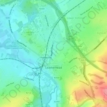
Name: Leatherhead topographic map, elevation, terrain.

Location: Leatherhead, Mole Valley, Surrey, England, United Kingdom (51.28413 -0.34710 51.31500 -0.31120)

Average elevation: 177 ft

Minimum elevation: 85 ft

Maximum elevation: 387 ft

Other topographic maps

Click on a map to view its topography, its elevation and its terrain.

Dorking

United Kingdom > England > Surrey > Mole Valley

Average elevation: 351 ft

Gear up for your next adventure:

🧢Sun Protection Hats - Wide-brimmed and UPF-rated hats for high-altitude sun safety
📡GPS Antenna Upgrade - Enhance GPS reception in remote terrain
🔭Compact Binoculars - HD vision for scouting terrain and identifying distant landmarks
🏕️Tent Footprint - Protect your tent base from wear
🚗GPS Dash Cams - Record your scenic drives through mountain passes and canyons

As an Amazon Associate, this site earns from qualifying purchases at no extra cost to you.