Geolocate

Masontown topographic map

Click on the map to display elevation.

About this map

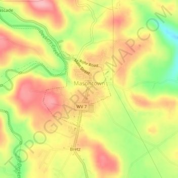
Name: Masontown topographic map, elevation, terrain.

Location: Masontown, Preston County, West Virginia, United States (39.54569 -79.80696 39.55716 -79.79361)

Average elevation: 1,775 ft

Minimum elevation: 1,526 ft

Maximum elevation: 1,952 ft

Preston County trails, hiking, mountain biking, running and outdoor activities

Other topographic maps

Click on a map to view its topography, its elevation and its terrain.

Anderson

United States > West Virginia > Preston County

Average elevation: 1,880 ft

Valley Point

United States > West Virginia > Preston County

Average elevation: 1,955 ft

Caddell

United States > West Virginia > Preston County

Average elevation: 1,598 ft

Anderson

United States > West Virginia > Preston County

Average elevation: 1,880 ft

Jessop

United States > West Virginia > Preston County

Average elevation: 2,021 ft

Caddell

United States > West Virginia > Preston County

Average elevation: 1,598 ft

Sell

United States > West Virginia > Preston County

Average elevation: 2,438 ft

Gladesville

United States > West Virginia > Preston County

Average elevation: 1,801 ft

Mountain Dale

United States > West Virginia > Preston County

Average elevation: 2,408 ft

Victoria

United States > West Virginia > Preston County

Average elevation: 1,555 ft

Preston

United States > West Virginia > Preston County > Preston

Average elevation: 1,647 ft

Gear up for your next adventure:

Camping Coffee Makers - Enjoy premium coffee at the summit or campsite
🛰️Handheld GPS Units - Professional satellite navigators for precise backcountry mapping
☀️Outdoor Sunscreen - High protection sunscreen for outdoor activities
🗺️NatGeo Topo Maps - High-quality waterproof printed topographic maps of US Parks
🧺Microfiber Travel Towels - Compact and fast-drying towels for trail use

As an Amazon Associate, this site earns from qualifying purchases at no extra cost to you.