
Thank you for supporting this site ❤️
Make a donation
Make a donation
Gear up for your next adventure:
As an Amazon Associate, this site earns from qualifying purchases at no extra cost to you.
Sadri topographic map
Click on the map to display elevation.
Thank you for supporting this site ❤️
Make a donation
Make a donation
Gear up for your next adventure:
As an Amazon Associate, this site earns from qualifying purchases at no extra cost to you.
Sadri
Sadri is located at 25°11′N 73°26′E / 25.18°N 73.43°E / 25.18; 73.43. It has an average elevation of 502 meters.
Thank you for supporting this site ❤️
Make a donation
Make a donation
Gear up for your next adventure:
As an Amazon Associate, this site earns from qualifying purchases at no extra cost to you.
About this map
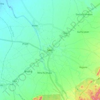
Name: Sadri topographic map, elevation, terrain.
Location: Sadri, Desuri Tehsil, Pali, Rajasthan, 306702, India (25.14665 73.41270 25.22665 73.49270)
Average elevation: 1,188 ft
Minimum elevation: 1,089 ft
Maximum elevation: 1,493 ft
Thank you for supporting this site ❤️
Make a donation
Make a donation
Gear up for your next adventure:
As an Amazon Associate, this site earns from qualifying purchases at no extra cost to you.