Geolocate

Sangole topographic map

Click on the map to display elevation.

About this map

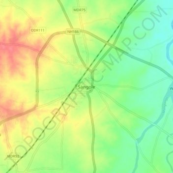
Name: Sangole topographic map, elevation, terrain.

Location: Sangole, Solapur District, Maharashtra, 413307, India (17.39627 75.15323 17.47627 75.23323)

Average elevation: 1,657 ft

Minimum elevation: 1,562 ft

Maximum elevation: 1,775 ft

Gear up for your next adventure:

🔦Compact Flashlight - Reliable flashlight for emergencies
🛠️Backpacking Tool Kit - Essential toolkit for outdoor repairs
🥾Hiking Shoes - Durable and comfortable shoes for trail hiking
🗻Climbing Gear Basics - Essential gear for beginner climbers
🪶Paracord Bracelet - Survival bracelet with built‑in tools

As an Amazon Associate, this site earns from qualifying purchases at no extra cost to you.