Geolocate

Hanover topographic map

Click on the map to display elevation.

About this map
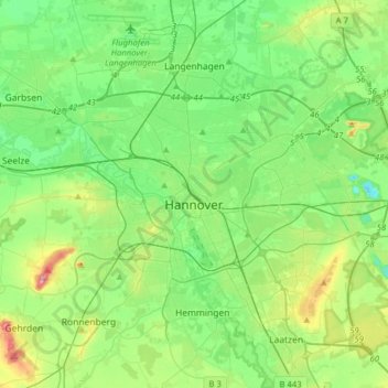
Name: Hanover topographic map, elevation, terrain.

Location: Hanover, Region Hannover, Lower Saxony, Germany (52.30489 9.60445 52.45433 9.91857)

Average elevation: 200 ft

Minimum elevation: 69 ft

Maximum elevation: 551 ft

Other topographic maps

Click on a map to view its topography, its elevation and its terrain.

Resse

Germany > Lower Saxony > Region Hannover

Average elevation: 157 ft

Kirchhorst

Germany > Lower Saxony > Region Hannover

Average elevation: 197 ft

Scherenbostel

Germany > Lower Saxony > Region Hannover

Average elevation: 197 ft

Dachtmissen

Germany > Lower Saxony > Region Hannover > Burgdorf

Average elevation: 174 ft

Liethe

Germany > Lower Saxony > Region Hannover > Wunstorf

Average elevation: 151 ft

Altwarmbüchen

Germany > Lower Saxony > Region Hannover

Average elevation: 187 ft

Gear up for your next adventure:

⛺Backpacking Tent - Lightweight and durable tent for multi‑day hikes
🧯Emergency Survival Kit - All‑in‑one survival essentials for the backcountry
🥘Titanium Cookware - Durable, featherlight pots and pans for backpacking
💧Water Purification System - Clean water on the trail with reliable purifiers
🛌Ultralight Sleeping Bags - Compact down bags for cold nights in the wilderness

As an Amazon Associate, this site earns from qualifying purchases at no extra cost to you.