Geolocate

Arlon topographic map

Click on the map to display elevation.

About this map

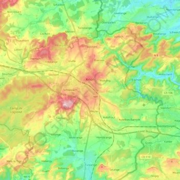
Name: Arlon topographic map, elevation, terrain.

Location: Arlon, Luxembourg, Wallonia, Belgium (49.62188 5.67846 49.72721 5.91068)

Average elevation: 1,138 ft

Minimum elevation: 876 ft

Maximum elevation: 1,535 ft

Gear up for your next adventure:

🛠️Backpacking Tool Kit - Essential toolkit for outdoor repairs
🥾Hiking Shoes - Durable and comfortable shoes for trail hiking
🪵Folding Camp Saw - Compact saw for wood and campsite work
👟Trail Running Shoes - Lightweight shoes for trail runners
🎒Trail Energy Bars - High‑calorie bars for hiking energy

As an Amazon Associate, this site earns from qualifying purchases at no extra cost to you.