
Make a donation
Gear up for your next adventure:
As an Amazon Associate, this site earns from qualifying purchases at no extra cost to you.
Lac Margie topographic map
Click on the map to display elevation.
Make a donation
Gear up for your next adventure:
As an Amazon Associate, this site earns from qualifying purchases at no extra cost to you.
About this map
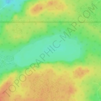
Name: Lac Margie topographic map, elevation, terrain.
Location: Lac Margie, Eeyou Istchee, Northern Quebec, Quebec, Canada (49.67456 -76.20281 49.68331 -76.17523)
Average elevation: 1,043 ft
Minimum elevation: 968 ft
Maximum elevation: 1,109 ft
Make a donation
Gear up for your next adventure:
As an Amazon Associate, this site earns from qualifying purchases at no extra cost to you.
Other topographic maps
Click on a map to view its topography, its elevation and its terrain.
Whapmagoostui (Category I Land)
Canada > Quebec > Eeyou Istchee > Whapmagoostui (Village)
Average elevation: 299 ft
Make a donation
Gear up for your next adventure:
As an Amazon Associate, this site earns from qualifying purchases at no extra cost to you.
Make a donation
Gear up for your next adventure:
As an Amazon Associate, this site earns from qualifying purchases at no extra cost to you.