
Exter topographic map
Interactive map
Click on the map to display elevation.
About this map
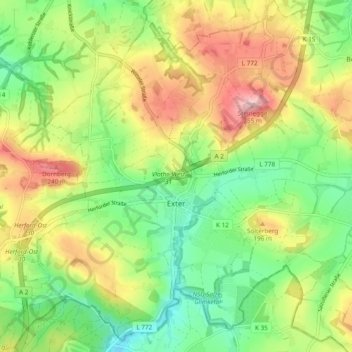
Name: Exter topographic map, elevation, terrain.
Location: Exter, Vlotho, Kreis Herford, Nordrhein-Westfalen, Deutschland (52.11216 8.72916 52.17091 8.81920)
Average elevation: 522 ft
Minimum elevation: 282 ft
Maximum elevation: 846 ft
Other topographic maps
Click on a map to view its topography, its elevation and its terrain.
Vlotho
Deutschland > Nordrhein-Westfalen > Kreis Herford > Vlotho
Vlotho, Kreis Herford, Nordrhein-Westfalen, 32602, Deutschland
Average elevation: 390 ft
Bonneberg
Deutschland > Nordrhein-Westfalen > Kreis Herford > Vlotho
Bonneberg, Vlotho, Kreis Herford, Nordrhein-Westfalen, 32602, Deutschland
Average elevation: 492 ft
NSG Eiberg
Deutschland > Nordrhein-Westfalen > Kreis Herford > Vlotho
NSG Eiberg, Lemgoer Straße, Beerenkämpen, Valdorf, Vlotho, Kreis Herford, Nordrhein-Westfalen, 32602, Deutschland
Average elevation: 545 ft
Uffeln
Deutschland > Nordrhein-Westfalen > Kreis Herford > Vlotho
Uffeln, Vlotho, Kreis Herford, Nordrhein-Westfalen, Deutschland
Average elevation: 341 ft