
Make a donation
Gear up for your next adventure:
As an Amazon Associate, this site earns from qualifying purchases at no extra cost to you.
Uffeln topographic map
Click on the map to display elevation.
Make a donation
Gear up for your next adventure:
As an Amazon Associate, this site earns from qualifying purchases at no extra cost to you.
Uffeln
Uffeln liegt als einziges Gebiet des Kreises Herford östlich der Weser und gehört damit geografisch nicht zum Ravensberger Land. Ein Großteil des Gebietes besteht aus dem bis zu 170 m hohen Höhenrücken Buhn. Dieser Hügel fällt an seiner südöstlichen steil ab. Sein Name ist gleichbedeutend mit erhöhter Fläche (vgl. das Wort Bühne). Er ragt zugleich wie eine Buhne in die Weser, die Uffeln in einem großen Bogen umrundet und die natürliche Ortsteilgrenze im Westen, Süden und Osten bildet. Buhn ist zugleich die Bezeichnung einer Ortslage.
Make a donation
Gear up for your next adventure:
As an Amazon Associate, this site earns from qualifying purchases at no extra cost to you.
About this map
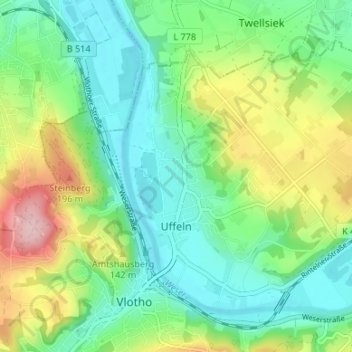
Name: Uffeln topographic map, elevation, terrain.
Location: Uffeln, Vlotho, Kreis Herford, Nordrhein-Westfalen, Deutschland (52.16527 8.86006 52.19690 8.92672)
Average elevation: 341 ft
Minimum elevation: 135 ft
Maximum elevation: 781 ft
Make a donation
Gear up for your next adventure:
As an Amazon Associate, this site earns from qualifying purchases at no extra cost to you.
Other topographic maps
Click on a map to view its topography, its elevation and its terrain.