Geolocate

Linden topographic map

Click on the map to display elevation.

About this map

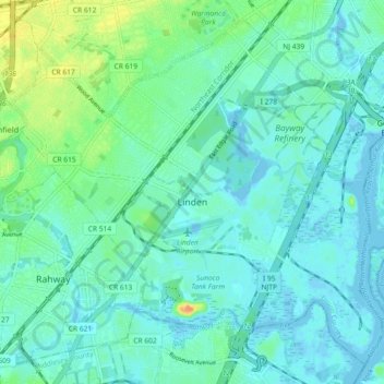
Name: Linden topographic map, elevation, terrain.

Location: Linden, Union County, New Jersey, United States (40.59264 -74.29070 40.65493 -74.19959)

Average elevation: 26 ft

Minimum elevation: -13 ft

Maximum elevation: 121 ft

Union County trails, hiking, mountain biking, running and outdoor activities

Other topographic maps

Click on a map to view its topography, its elevation and its terrain.

Tremley

United States > New Jersey > Union County > Linden

Average elevation: 13 ft

Woodland Park

United States > New Jersey > Union County > Summit

Average elevation: 361 ft

Tremont Park

United States > New Jersey > Union County > Summit

Average elevation: 335 ft

Woodland Park

United States > New Jersey > Union County > Summit

Average elevation: 361 ft

Gear up for your next adventure:

📶Satellite Messenger - Communication device off‑grid
Backpacking Tents - Weight-optimized shelters for multi-day topographic surveys
📚USA Hiking Guide Books - Top trail guides and map books
🎒Trekking Poles - Sturdy poles for balance and stability on rough terrain
🔊Portable Camp Speaker - Music and alerts at camp

As an Amazon Associate, this site earns from qualifying purchases at no extra cost to you.