
Make a donation
Gear up for your next adventure:
As an Amazon Associate, this site earns from qualifying purchases at no extra cost to you.
Afognak Island topographic map
Click on the map to display elevation.
Make a donation
Gear up for your next adventure:
As an Amazon Associate, this site earns from qualifying purchases at no extra cost to you.
About this map
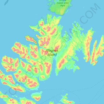
Name: Afognak Island topographic map, elevation, terrain.
Average elevation: 233 ft
Minimum elevation: -7 ft
Maximum elevation: 2,398 ft
Kodiak Island Borough trails, hiking, mountain biking, running and outdoor activities
Make a donation
Gear up for your next adventure:
As an Amazon Associate, this site earns from qualifying purchases at no extra cost to you.
Other topographic maps
Click on a map to view its topography, its elevation and its terrain.
Mount Katmai
United States > Alaska > Kodiak Island Borough
Mount Katmai (Russian: Катмай) is a large active stratovolcano (composite volcano) on the Alaska Peninsula in southern Alaska, located within Katmai National Park and Preserve. It is about 6.3 miles (10 km) in diameter with a central lake-filled caldera about two by three miles (3.2 by 4.8 km) in size,…
Average elevation: 4,970 ft
Make a donation
Gear up for your next adventure:
As an Amazon Associate, this site earns from qualifying purchases at no extra cost to you.