Geolocate

Carletonville topographic map

Click on the map to display elevation.

About this map

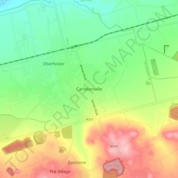
Name: Carletonville topographic map, elevation, terrain.

Location: Carletonville, Merafong City Local Municipality, West Rand District Municipality, Gauteng, 2500, South Africa (-26.40144 27.36192 -26.32144 27.44192)

Average elevation: 5,049 ft

Minimum elevation: 4,797 ft

Maximum elevation: 5,417 ft

Other topographic maps

Click on a map to view its topography, its elevation and its terrain.

Gear up for your next adventure:

📶Vehicle Signal Boosters - Improve reception in rural areas while driving to trailheads
🥇GPS Hiking Watch - Multi‑sport GPS watch with navigation and trail tracking
🧤Tactile Hiking Gloves - Keep hands warm while operating GPS and smartphone screens
🔭Compact Binoculars - HD vision for scouting terrain and identifying distant landmarks
🏥Hiking First Aid Kits - Comprehensive medical kits for remote trail injuries

As an Amazon Associate, this site earns from qualifying purchases at no extra cost to you.