
Make a donation
Gear up for your next adventure:
As an Amazon Associate, this site earns from qualifying purchases at no extra cost to you.
Grayson topographic map
Click on the map to display elevation.
Make a donation
Gear up for your next adventure:
As an Amazon Associate, this site earns from qualifying purchases at no extra cost to you.
About this map
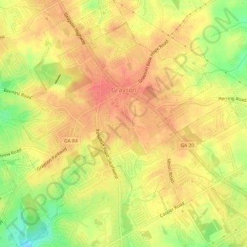
Name: Grayson topographic map, elevation, terrain.
Location: Grayson, Gwinnett County, Georgia, United States (33.87176 -83.97670 33.90707 -83.93570)
Average elevation: 1,047 ft
Minimum elevation: 925 ft
Maximum elevation: 1,112 ft
Gwinnett County trails, hiking, mountain biking, running and outdoor activities
Make a donation
Gear up for your next adventure:
As an Amazon Associate, this site earns from qualifying purchases at no extra cost to you.
Other topographic maps
Click on a map to view its topography, its elevation and its terrain.
Settles Bridge
United States > Georgia > Gwinnett County > Suwanee > Settles Bridge
Average elevation: 1,030 ft
Make a donation
Gear up for your next adventure:
As an Amazon Associate, this site earns from qualifying purchases at no extra cost to you.
Make a donation
Gear up for your next adventure:
As an Amazon Associate, this site earns from qualifying purchases at no extra cost to you.
Rock Creek Estates
United States > Georgia > Gwinnett County > Buford > Rock Creek Estates
Average elevation: 1,109 ft