
Make a donation
Gear up for your next adventure:
As an Amazon Associate, this site earns from qualifying purchases at no extra cost to you.
El Pedregal topographic map
Click on the map to display elevation.
Make a donation
Gear up for your next adventure:
As an Amazon Associate, this site earns from qualifying purchases at no extra cost to you.
El Pedregal
El Pedregal es una localidad peruana, capital del distrito de Majes, ubicado en la provincia de Caylloma, en el departamento de Arequipa. Se encuentra a una altitud de 1410 m s. n. m. Tenía una población de 2573 hab. en 1993.
Make a donation
Gear up for your next adventure:
As an Amazon Associate, this site earns from qualifying purchases at no extra cost to you.
About this map
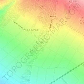
Name: El Pedregal topographic map, elevation, terrain.
Location: El Pedregal, Majes, Caylloma, Arequipa, Perú (-16.40199 -72.23088 -16.32199 -72.15088)
Average elevation: 4,554 ft
Minimum elevation: 3,711 ft
Maximum elevation: 5,052 ft
Make a donation
Gear up for your next adventure:
As an Amazon Associate, this site earns from qualifying purchases at no extra cost to you.
Other topographic maps
Click on a map to view its topography, its elevation and its terrain.