
Thank you for supporting this site ❤️
Make a donation
Make a donation
Gear up for your next adventure:
As an Amazon Associate, this site earns from qualifying purchases at no extra cost to you.
Massaprofoglio topographic map
Click on the map to display elevation.
Thank you for supporting this site ❤️
Make a donation
Make a donation
Gear up for your next adventure:
As an Amazon Associate, this site earns from qualifying purchases at no extra cost to you.
About this map
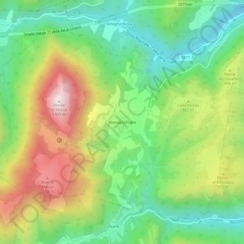
Name: Massaprofoglio topographic map, elevation, terrain.
Location: Massaprofoglio, Muccia, Macerata, Italia (43.03946 12.98302 43.07946 13.02302)
Average elevation: 2,608 ft
Minimum elevation: 1,572 ft
Maximum elevation: 4,226 ft
Thank you for supporting this site ❤️
Make a donation
Make a donation
Gear up for your next adventure:
As an Amazon Associate, this site earns from qualifying purchases at no extra cost to you.