
Jordanshöhe topographic map
Interactive map
Click on the map to display elevation.
Jordanshöhe
Die Jordanshöhe aus westlicher Richtung
About this map
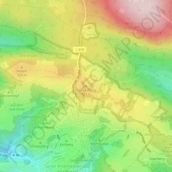
Name: Jordanshöhe topographic map, elevation, terrain.
Average elevation: 2,205 ft
Minimum elevation: 1,650 ft
Maximum elevation: 2,825 ft
Other topographic maps
Click on a map to view its topography, its elevation and its terrain.
Sonnenberg
Deutschland > Niedersachsen > Landkreis Goslar > Braunlage > Sankt Andreasberg
Average elevation: 2,543 ft
Sankt Andreasberg
Deutschland > Niedersachsen > Landkreis Goslar > Braunlage
Sankt Andreasberg liegt zwischen Braunlage im Osten, Herzberg am Harz im Westen, Bad Lauterberg im Süden sowie Clausthal-Zellerfeld und Altenau im Nordwesten im Naturpark Harz am Rand des Nationalparks Harz. Sankt Andreasberg ist „eingeschlossen“ vom gemeindefreien Gebiet Harz. Die Bergstadt befindet sich…
Average elevation: 2,126 ft
Waldhaus
Deutschland > Niedersachsen > Landkreis Goslar > Braunlage > Sankt Andreasberg
Average elevation: 1,857 ft