
Make a donation
Gear up for your next adventure:
As an Amazon Associate, this site earns from qualifying purchases at no extra cost to you.
Rindge topographic map
Click on the map to display elevation.
Make a donation
Gear up for your next adventure:
As an Amazon Associate, this site earns from qualifying purchases at no extra cost to you.
Rindge
According to the United States Census Bureau, the town has a total area of 39.8 square miles (103.1 km2), of which 37.1 square miles (96.1 km2) are land and 2.7 square miles (7.0 km2) are water, comprising 6.76% of the town. Rindge is located in a hilly upland lake region. Hubbard Pond is in the northeast, Contoocook Lake on the northern boundary, Pearly Lake is in the northwest, and Lake Monomonac is on the southern boundary. The town is located on a regional watershed divide and is the headwaters for two river systems. The Contoocook River flows north to the Merrimack River, thence to the Gulf of Maine, and the North Branch of the Millers River flows southwest to the Connecticut River, thence to Long Island Sound. Rindge's highest point is on its eastern border, on the lower slopes of Pratt Mountain, where the elevation reaches 1,505 feet (459 m) above sea level.
Make a donation
Gear up for your next adventure:
As an Amazon Associate, this site earns from qualifying purchases at no extra cost to you.
About this map
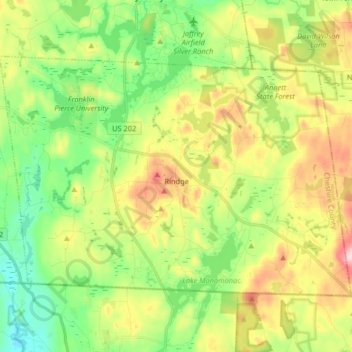
Name: Rindge topographic map, elevation, terrain.
Location: Rindge, Cheshire County, New Hampshire, United States (42.71216 -72.09185 42.79370 -71.92886)
Average elevation: 1,125 ft
Minimum elevation: 837 ft
Maximum elevation: 1,578 ft
Cheshire County trails, hiking, mountain biking, running and outdoor activities
Make a donation
Gear up for your next adventure:
As an Amazon Associate, this site earns from qualifying purchases at no extra cost to you.
Other topographic maps
Click on a map to view its topography, its elevation and its terrain.
Stone Pond
United States > New Hampshire > Cheshire County > Marlow > Gee Mill
Average elevation: 1,411 ft
Mount Monadnock
United States > New Hampshire > Cheshire County > Jaffrey
From the base to the summit, floral species diminish with increasingly shallow soil levels. The summit is home to many different specialized sub-alpine species which can retain moisture for long periods of time. Alpine and sub-alpine species include mountain ash, cotton grass, sheep laurel, mountain sandwort,…
Average elevation: 2,254 ft
Make a donation
Gear up for your next adventure:
As an Amazon Associate, this site earns from qualifying purchases at no extra cost to you.
Camp Notre Dame
United States > New Hampshire > Cheshire County > Chesterfield
Average elevation: 732 ft
Mount Monadnock
United States > New Hampshire > Cheshire County > Jaffrey
From the base to the summit, floral species diminish with increasingly shallow soil levels. The summit is home to many different specialized sub-alpine species which can retain moisture for long periods of time. Alpine and sub-alpine species include mountain ash, cotton grass, sheep laurel, mountain sandwort,…
Average elevation: 2,254 ft
Make a donation
Gear up for your next adventure:
As an Amazon Associate, this site earns from qualifying purchases at no extra cost to you.
Mount Monadnock
United States > New Hampshire > Cheshire County > Jaffrey
From the base to the summit, floral species diminish with increasingly shallow soil levels. The summit is home to many different specialized sub-alpine species which can retain moisture for long periods of time. Alpine and sub-alpine species include mountain ash, cotton grass, sheep laurel, mountain sandwort,…
Average elevation: 2,254 ft
Gilboa Mountain
United States > New Hampshire > Cheshire County > Westmoreland
Average elevation: 1,086 ft
West Chesterfield
United States > New Hampshire > Cheshire County > Chesterfield
Average elevation: 551 ft
Make a donation
Gear up for your next adventure:
As an Amazon Associate, this site earns from qualifying purchases at no extra cost to you.