
Thank you for supporting this site ❤️
Make a donation
Make a donation
Gear up for your next adventure:
As an Amazon Associate, this site earns from qualifying purchases at no extra cost to you.
Köselerli topographic map
Click on the map to display elevation.
Thank you for supporting this site ❤️
Make a donation
Make a donation
Gear up for your next adventure:
As an Amazon Associate, this site earns from qualifying purchases at no extra cost to you.
About this map
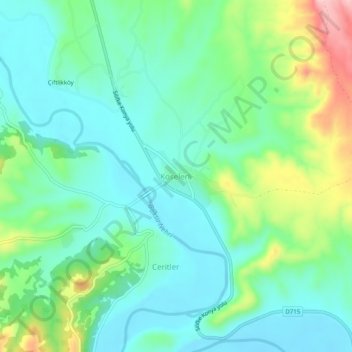
Name: Köselerli topographic map, elevation, terrain.
Location: Köselerli, Mut, Mersin, Mediterranean Region, Turkey (36.53254 33.43160 36.57254 33.47160)
Average elevation: 479 ft
Minimum elevation: 308 ft
Maximum elevation: 925 ft
Thank you for supporting this site ❤️
Make a donation
Make a donation
Gear up for your next adventure:
As an Amazon Associate, this site earns from qualifying purchases at no extra cost to you.