
Make a donation
Gear up for your next adventure:
As an Amazon Associate, this site earns from qualifying purchases at no extra cost to you.
Malesherbes topographic map
Click on the map to display elevation.
Make a donation
Gear up for your next adventure:
As an Amazon Associate, this site earns from qualifying purchases at no extra cost to you.
Malesherbes
La superficie de la commune est de 1 761 hectares ; son altitude varie entre 67 et 140 mètres.
Make a donation
Gear up for your next adventure:
As an Amazon Associate, this site earns from qualifying purchases at no extra cost to you.
About this map
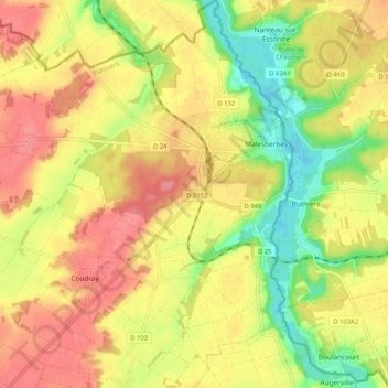
Name: Malesherbes topographic map, elevation, terrain.
Average elevation: 361 ft
Minimum elevation: 217 ft
Maximum elevation: 472 ft
Make a donation
Gear up for your next adventure:
As an Amazon Associate, this site earns from qualifying purchases at no extra cost to you.
Other topographic maps
Click on a map to view its topography, its elevation and its terrain.
Oinville
France > Centre-Val de Loire > Loiret > Le Malesherbois > Lieu-Dit Oinville
Average elevation: 440 ft
Malesherbes
France > Centre-Val de Loire > Loiret > Le Malesherbois
La superficie de la commune est de 1 761 hectares ; son altitude varie entre 67 et 140 mètres.
Average elevation: 335 ft
Make a donation
Gear up for your next adventure:
As an Amazon Associate, this site earns from qualifying purchases at no extra cost to you.