
Make a donation
Gear up for your next adventure:
As an Amazon Associate, this site earns from qualifying purchases at no extra cost to you.
Osijek topographic map
Click on the map to display elevation.
Make a donation
Gear up for your next adventure:
As an Amazon Associate, this site earns from qualifying purchases at no extra cost to you.
Osijek
Osijek (Croatian pronunciation: [ôsijeːk] ) is the largest city and the economic and cultural hub of the eastern Croatian region of Slavonia, as well as the administrative seat of Osijek-Baranja County. It is the fourth-largest city in Croatia, with a population of 96,313 recorded in the 2021 census. The city is situated on the southern bank of the Drava River, 25 km (16 mi) upstream from its confluence with the Danube, at an elevation of 94 m (308 ft). Osijek is located 16 km (10 mi) west of the Croatia–Serbia border.
Make a donation
Gear up for your next adventure:
As an Amazon Associate, this site earns from qualifying purchases at no extra cost to you.
About this map
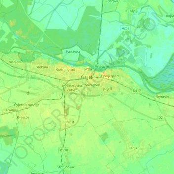
Name: Osijek topographic map, elevation, terrain.
Location: Osijek, Grad Osijek, Osijek-Baranja County, Croatia (45.51407 18.59620 45.58006 18.78136)
Average elevation: 285 ft
Minimum elevation: 256 ft
Maximum elevation: 331 ft
Make a donation
Gear up for your next adventure:
As an Amazon Associate, this site earns from qualifying purchases at no extra cost to you.
Other topographic maps
Click on a map to view its topography, its elevation and its terrain.
Osijek
Croatia > Osijek-Baranja County > Osijek
Osijek (Croatian pronunciation: (listen)) is the fourth largest city in Croatia with a population of 108,048 in 2011. It is the largest city and the economic and cultural centre of the eastern Croatian region of Slavonia, as well as the administrative centre of Osijek-Baranja County. Osijek is located on the…
Average elevation: 285 ft
Make a donation
Gear up for your next adventure:
As an Amazon Associate, this site earns from qualifying purchases at no extra cost to you.