
Make a donation
Gear up for your next adventure:
As an Amazon Associate, this site earns from qualifying purchases at no extra cost to you.
Carlsbad topographic map
Click on the map to display elevation.
Make a donation
Gear up for your next adventure:
As an Amazon Associate, this site earns from qualifying purchases at no extra cost to you.
Carlsbad
Carlsbad is located near the center of Eddy County at 32°24′43″N 104°14′11″W / 32.41194°N 104.23639°W / 32.41194; -104.23639 (32.407577, -104.245167) at an elevation of 3,295 feet (1,004 m). Carlsbad is situated in the northern reaches of the Chihuahuan Desert ecoregion, in the lower Pecos River Valley. Via US 285 it is 36 miles (58 km) north to Artesia and 86 miles (138 km) south to Pecos, Texas. US Routes 62 and 180 lead northeast 69 miles (111 km) to Hobbs and southwest 169 miles (272 km) to El Paso.
Make a donation
Gear up for your next adventure:
As an Amazon Associate, this site earns from qualifying purchases at no extra cost to you.
About this map
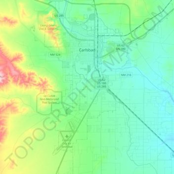
Name: Carlsbad topographic map, elevation, terrain.
Location: Carlsbad, Eddy County, New Mexico, United States (32.29829 -104.28964 32.47653 -104.13431)
Average elevation: 3,225 ft
Minimum elevation: 3,035 ft
Maximum elevation: 3,802 ft
Eddy County trails, hiking, mountain biking, running and outdoor activities
Make a donation
Gear up for your next adventure:
As an Amazon Associate, this site earns from qualifying purchases at no extra cost to you.
Other topographic maps
Click on a map to view its topography, its elevation and its terrain.
Make a donation
Gear up for your next adventure:
As an Amazon Associate, this site earns from qualifying purchases at no extra cost to you.