Geolocate

Brasil topographic map

Click on the map to display elevation.

About this map

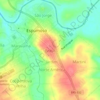
Name: Brasil topographic map, elevation, terrain.

Location: Brasil, Espumoso, Região Geográfica Imediata de Passo Fundo, Região Geográfica Intermediária de Passo Fundo, Rio Grande do Sul, Região Sul, Brasil (-28.73277 -52.84336 -28.72927 -52.83919)

Average elevation: 1,227 ft

Minimum elevation: 1,125 ft

Maximum elevation: 1,345 ft

Other topographic maps

Click on a map to view its topography, its elevation and its terrain.

Arroio da Prata

Brasil > Rio Grande do Sul > Espumoso

Average elevation: 1,306 ft

Gear up for your next adventure:

🛡️Insect Repellent - Protection against bugs during outdoor activities
📷Action Cameras - Rugged cameras to document your journeys across rugged terrain
🧥Men's Rain Shells - Premium waterproof and breathable jackets for mountain weather
🥄Camping Utensil Set - Lightweight utensils for outdoor meals
🌡️Handheld Weather Meters - Measure wind, temp, and pressure for safe mountain travel

As an Amazon Associate, this site earns from qualifying purchases at no extra cost to you.