
Saltillo topographic map
Interactive map
Click on the map to display elevation.
About this map
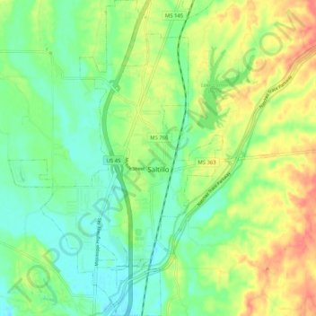
Name: Saltillo topographic map, elevation, terrain.
Location: Saltillo, Lee County, Mississippi, United States (34.33736 -88.73303 34.42177 -88.66357)
Average elevation: 344 ft
Minimum elevation: 269 ft
Maximum elevation: 453 ft
Other topographic maps
Click on a map to view its topography, its elevation and its terrain.
Plantersville
United States > Mississippi > Lee County
Plantersville, Lee County, Mississippi, United States
Average elevation: 276 ft
Tupelo
United States > Mississippi > Lee County
Tupelo, Lee County, Mississippi, United States
Average elevation: 308 ft
Baldwyn
United States > Mississippi > Lee County
Baldwyn, Lee County, Mississippi, 38824, United States
Average elevation: 358 ft
Tombigbee State Park
United States > Mississippi > Lee County
Tombigbee State Park, Lee County, Mississippi, United States
Average elevation: 381 ft