Geolocate

Baldwyn topographic map

Click on the map to display elevation.

About this map

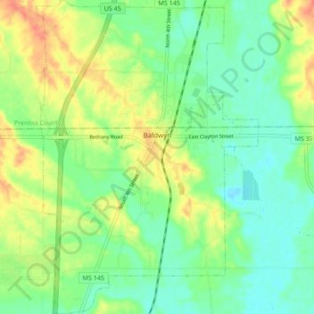
Name: Baldwyn topographic map, elevation, terrain.

Location: Baldwyn, Lee County, Mississippi, 38824, United States (34.46984 -88.66794 34.53946 -88.60805)

Average elevation: 358 ft

Minimum elevation: 302 ft

Maximum elevation: 443 ft

Lee County trails, hiking, mountain biking, running and outdoor activities

Other topographic maps

Click on a map to view its topography, its elevation and its terrain.

Gear up for your next adventure:

🧭Map Reading Tools - Tools and kits for map navigation
🏥Hiking First Aid Kits - Comprehensive medical kits for remote trail injuries
🔥Plasma Lighters - Windproof lighters that work in any weather condition
🛌Ultralight Sleeping Bags - Compact down bags for cold nights in the wilderness
📱Solar Portable Charger - Solar power bank for charging devices off‑grid

As an Amazon Associate, this site earns from qualifying purchases at no extra cost to you.