Geolocate

Keswick topographic map

Click on the map to display elevation.

About this map

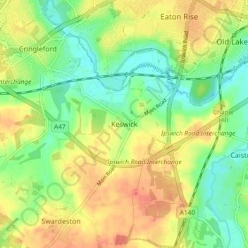
Name: Keswick topographic map, elevation, terrain.

Location: Keswick, South Norfolk, Norfolk, England, NR4 6TY, United Kingdom (52.57217 1.24301 52.61217 1.28301)

Average elevation: 75 ft

Minimum elevation: 3 ft

Maximum elevation: 144 ft

Other topographic maps

Click on a map to view its topography, its elevation and its terrain.

Kirby Cane

United Kingdom > England > Norfolk > South Norfolk

Average elevation: 72 ft

Mulbarton

United Kingdom > England > Norfolk > South Norfolk

Average elevation: 135 ft

Alburgh

United Kingdom > England > Norfolk > South Norfolk > Alburgh Street

Average elevation: 141 ft

Haddiscoe

United Kingdom > England > Norfolk > South Norfolk

Average elevation: 23 ft

Loddon

United Kingdom > England > Norfolk > South Norfolk > Chedgrave

Average elevation: 66 ft

Gear up for your next adventure:

🎒Hydration Pack - Hands‑free water reservoir for long hikes
🦺Reflective Outdoor Gear - Safety gear for low‑light conditions
🥤Water Filter Bottle - All‑in‑one filter bottle for safe hydration
📱Solar Portable Charger - Solar power bank for charging devices off‑grid
🛌Ultralight Sleeping Bags - Compact down bags for cold nights in the wilderness

As an Amazon Associate, this site earns from qualifying purchases at no extra cost to you.