Geolocate

Easly topographic map

Click on the map to display elevation.

About this map

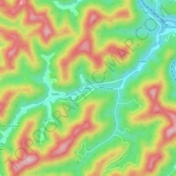
Name: Easly topographic map, elevation, terrain.

Location: Easly, Boone County, West Virginia, 25142, United States (38.13232 -81.75318 38.17232 -81.71318)

Average elevation: 1,047 ft

Minimum elevation: 630 ft

Maximum elevation: 1,526 ft

Boone County trails, hiking, mountain biking, running and outdoor activities

Other topographic maps

Click on a map to view its topography, its elevation and its terrain.

Whitesville

United States > West Virginia > Boone County

Average elevation: 1,352 ft

Madison

United States > West Virginia > Boone County

Average elevation: 1,066 ft

Danville

United States > West Virginia > Boone County

Average elevation: 919 ft

Sylvester

United States > West Virginia > Boone County

Average elevation: 1,266 ft

Gear up for your next adventure:

🧥Men's Rain Shells - Premium waterproof and breathable jackets for mountain weather
🧦Hiking Socks - Comfortable socks to prevent blisters on long hikes
🛶Inflatable Kayak - Portable kayak for rivers, lakes, and expeditions
🪶Camp Gear Gift Set - Perfect gift bundle for outdoor fans
🏔️Mountain Trail Maps - High‑detail maps for popular peaks

As an Amazon Associate, this site earns from qualifying purchases at no extra cost to you.