
Votorantim topographic map
Click on the map to display elevation.
Votorantim
Em 1914, foi construída a usina hidrelétrica de Itupararanga, aproveitando a topografia do município e seu potencial hidrelétrico. Outras usinas no rio Grande vieram na sequência, como Light, Santa Helena, Votocel e Cachoeira da Chave.
About this map
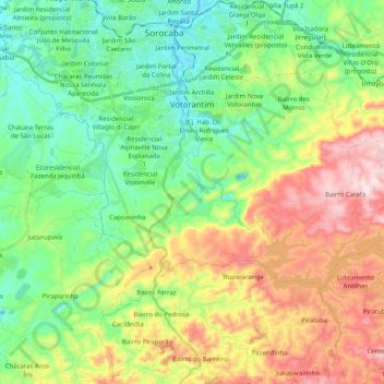
Name: Votorantim topographic map, elevation, terrain.
Location: Votorantim, São Paulo, Região Sudeste, Brasil (-23.65001 -47.51851 -23.51911 -47.29713)
Average elevation: 2,352 ft
Minimum elevation: 1,791 ft
Maximum elevation: 3,366 ft
Other topographic maps
Click on a map to view its topography, its elevation and its terrain.
São Paulo
Brasil > São Paulo > Região Metropolitana de São Paulo
A geologia local é constituída por terrenos policíclicos. representados por rochas metamórficas, migmatitos e granitoides, onde assentam-se sedimentos cenozoicos das bacias sedimentares locais. A altitude do município, tomando como referência o marco zero da cidade na Praça da Sé, é de 760 metros,…
Average elevation: 2,575 ft
Piracicaba
Brasil > São Paulo > Região Metropolitana de Piracicaba > Piracicaba
No relevo de Piracicaba apresenta-se predominância de áreas acidentadas, sendo que a depressão é maior na parte central de seu território. Ela continua pelo sentido leste-oeste do curso do rio Piracicaba, aumentando sua acentuação no interior da zona urbana a partir do salto do rio Piracicaba. Essa…
Average elevation: 1,827 ft
São José dos Campos
Brasil > São Paulo > São José dos Campos
No relevo de São José dos Campos apresenta-se predominância de áreas com colinas, que são mais acentuadas a norte, cujas alturas variam de 660 a 975 metros; os chamados mares de morros. Onde está a parte urbana da cidade essas colinas se transformam em terraços tabulares. As serras do Planalto…
Average elevation: 2,087 ft
Alagamento / Inundação
Brasil > São Paulo > Região Metropolitana de Piracicaba > Limeira
Average elevation: 1,864 ft
Rio Claro-SP
Brasil > São Paulo > Região Metropolitana de Piracicaba > Rio Claro
Average elevation: 2,005 ft
São José do Rio Pardo
Brasil > São Paulo > São José do Rio Pardo > São José do Rio Pardo
Average elevation: 2,507 ft
Ilha da Queimada Grande
A ilha possui aproximadamente 430.000m², topografia irregular e altitude máxima de 206 m. A profundidade ao redor pode chegar até 45 m. Não possui praias, somente costões rochosos. Um farol automático está instalado na parte mais plana da ilha, mantido e conservado pela Marinha.
Average elevation: 10 ft
Ilha Porchat
Brasil > São Paulo > Região Metropolitana da Baixada Santista > São Vicente
Average elevation: 863 ft
Rio Cotia
Brasil > São Paulo > Região Metropolitana de São Paulo > Carapicuíba
Average elevation: 2,520 ft
Santa Bárbara d'Oeste
Brasil > São Paulo > Região Metropolitana de Campinas > Santa Bárbara d'Oeste
Average elevation: 1,903 ft
São Carlos
A bacia do córrego do Gregório, que nasce em área rural, a leste da cidade de São Carlos, numa região de aproximadamente 900 metros de altitude (onde nascem também o rio Monjolinho e o ribeirão dos Negros, importantes cursos d'água deste município). Tem como afluentes pela margem direita o córrego…
Average elevation: 2,546 ft
Rio Tietê
Brasil > São Paulo > Região Metropolitana de São Paulo > São Paulo
Average elevation: 2,454 ft
Rio Juqueriquerê
Brasil > São Paulo > Região Metropolitana do Vale do Paraíba e Litoral Norte > Caraguatatuba
Average elevation: 696 ft
Rio Itaguaré
Brasil > São Paulo > Região Metropolitana da Baixada Santista > Bertioga
Average elevation: 10 ft
Parque da Aclimação
Brasil > São Paulo > Região Metropolitana de São Paulo > São Paulo
Average elevation: 2,549 ft
Ribeira
Brasil > São Paulo > Ribeira > Ribeira
Ribeira é um município brasileiro do estado de São Paulo. Localiza-se na região do Vale do Ribeira a uma latitude 24º39'25" sul e a uma longitude 49º00'32" oeste, estando a uma altitude de 167 metros. Sua população estimada em 2010 era de 3.358 habitantes. Possui uma área de 335,77 km².
Average elevation: 1,270 ft
Sorocaba
Brasil > São Paulo > Região Metropolitana de Sorocaba > Sorocaba
O relevo é classificado como ondulado, caracterizado por vertentes e altos de serra, com altitude média de 632 metros em relação ao nível do mar. A maior altitude é de 1.028 metros, nas cabeceiras do rio Pirajibu, na Serra de São Francisco, próximo a Alumínio. A menor altitude 539 metros está no vale…
Average elevation: 2,172 ft
Serra do Mar
Brasil > São Paulo > Região Metropolitana do Vale do Paraíba e Litoral Norte > Ubatuba
Average elevation: 2,470 ft
Jardim São Paulo
Brasil > São Paulo > Região Metropolitana de Sorocaba > Sorocaba
Average elevation: 2,060 ft
Fazenda Boa Vista
Brasil > São Paulo > Região Metropolitana de Sorocaba > Sarapuí
Average elevation: 1,873 ft
Praça Ibrahim de Almeida Nobre
Brasil > São Paulo > Região Metropolitana de São Paulo > São Bernardo do Campo
Average elevation: 2,549 ft
Praça Conceição Aparecida de Souza Aguiar
Brasil > São Paulo > Região Metropolitana de São Paulo > São Paulo
Average elevation: 2,546 ft
Praça Mateus Leme
Brasil > São Paulo > Região Metropolitana de São Paulo > São Paulo
Average elevation: 2,533 ft
Ferraz de Vasconcelos
Brasil > São Paulo > Região Metropolitana de São Paulo
Ferraz de Vasconcelos é um dos 39 municípios da Grande São Paulo, pertencente a região do Alto Tietê que contempla dez municípios, contando com uma densidade demográfica elevada e com alto índice de desenvolvimento humano - IDH, sua altitude em relação ao mar, situa-se entre 759 e 760 metros. Quando…
Average elevation: 2,546 ft
Parque em frente ao museu
Brasil > São Paulo > Região Metropolitana de São Paulo > Franco da Rocha
Average elevation: 2,510 ft
MAAS(Museu Aberto de Astronomia)
Brasil > São Paulo > Região Metropolitana de Campinas > Campinas
Average elevation: 3,081 ft
Santa Branca
Brasil > São Paulo > Região Metropolitana do Vale do Paraíba e Litoral Norte > Santa Branca
Average elevation: 2,162 ft
Praça Angélica Santiago Souza
Brasil > São Paulo > Região Metropolitana de São Paulo > São Paulo
Average elevation: 2,664 ft
Centro
Brasil > São Paulo > Região Metropolitana da Baixada Santista > Santos
Average elevation: 46 ft
Parque Ecológico Municipal Zila Sisternas Fiorenzo – da Biquinha
Brasil > São Paulo > Região Metropolitana de Sorocaba > Sorocaba
Average elevation: 1,906 ft
Matinho
Brasil > São Paulo > Região Metropolitana de São Paulo > São Paulo
Average elevation: 2,579 ft
Ribeirão Jacuba
Brasil > São Paulo > Região Metropolitana de Campinas > Hortolândia
Average elevation: 1,991 ft
Rio Cubatão
Brasil > São Paulo > Região Metropolitana da Baixada Santista > Cubatão
Average elevation: 30 ft
Praça da santa
Brasil > São Paulo > Região Metropolitana da Baixada Santista > Santos
Average elevation: 115 ft
Praça da Bíblia
Brasil > São Paulo > Região Metropolitana de Sorocaba > Cesário Lange
Average elevation: 2,041 ft
Jardim Itália
Brasil > São Paulo > Região Metropolitana de Sorocaba > Sorocaba
Average elevation: 1,886 ft
Praia de Pernambuco
Brasil > São Paulo > Região Metropolitana da Baixada Santista > Guarujá
Average elevation: 30 ft
Jardim Fátima
Brasil > São Paulo > Região Metropolitana de Sorocaba > Sorocaba
Average elevation: 1,870 ft
Pico dos Marins
Brasil > São Paulo > Região Metropolitana do Vale do Paraíba e Litoral Norte > Cruzeiro
O conjunto principal do Maciço dos Marins é constituído por três pontiagudos cumes de pedra, todos com mais de 2000 metros de altitude e centenas de metros de belos penhascos rochosos. O pico dos Marins, embora seja o mais elevado, é o mais acessível aos montanhistas, graças à sua face norte, menos…
Average elevation: 6,381 ft
Praça Professora Amélia Cesar Machado de Araújo
Brasil > São Paulo > Região Metropolitana de Sorocaba > Sorocaba
Average elevation: 2,014 ft
Ilhote Praia Grande
Brasil > São Paulo > Região Metropolitana da Baixada Santista > Guarujá
Average elevation: 174 ft
Praça Martinho Guedes
Brasil > São Paulo > Região Metropolitana de Sorocaba > Tatuí
Average elevation: 1,949 ft
Nascente (Afloramento D'água do Lençol Fréatico)
Brasil > São Paulo > Região Metropolitana de São Paulo > Franco da Rocha
Average elevation: 2,507 ft
Pedra da Mina
Brasil > São Paulo > Região Metropolitana do Vale do Paraíba e Litoral Norte > Queluz
A Pedra da Mina, ou ocasionalmente o pico da Pedra da Mina, é oficialmente a quarta montanha mais alta do Brasil, com 2798 metros de altitude.
Average elevation: 7,887 ft
Morro do Saboó
Brasil > São Paulo > Região Metropolitana de Sorocaba > São Roque
Average elevation: 2,543 ft
Praça João Lino de Queiroz
Brasil > São Paulo > Região Metropolitana de Piracicaba > Leme
Average elevation: 2,034 ft
Condominio JD São pedro
Brasil > São Paulo > Região Metropolitana de São Paulo > Itapecerica da Serra
Average elevation: 2,530 ft
Parque Florestal Municipal Pedro Paes de Almeida
Brasil > São Paulo > Região Metropolitana de Sorocaba > Sorocaba
Average elevation: 1,913 ft
Pico do Jaraguá
Brasil > São Paulo > São Paulo
Pico do Jaraguá é um dos pontos mais altos do município de São Paulo, no Brasil, elevando-se a uma altitude de 1 135 metros. Situa-se no bairro do Jaraguá, a oeste da serra da Cantareira. Nos seus arredores, foi criado o Parque Estadual do Jaraguá, para conservação da área.
Average elevation: 2,828 ft
Mata de Transição entre dois biomas (Mata Atlântica e Cerrado)
Average elevation: 2,615 ft
Praia do Félix
Brasil > São Paulo > Região Metropolitana do Vale do Paraíba e Litoral Norte > Ubatuba
Average elevation: 404 ft
Brigadeiro Tobias
Brasil > São Paulo > Região Metropolitana de Sorocaba > Sorocaba
Average elevation: 2,198 ft
Parque Municipal Benemérito José Brás
Brasil > São Paulo > Região Metropolitana de São Paulo > São Paulo
Average elevation: 2,411 ft
Boiçucanga
Brasil > São Paulo > Região Metropolitana do Vale do Paraíba e Litoral Norte > São Sebastião
Average elevation: 246 ft
Parque Estadual da Cantareira Núcleo Pedra Grande
Brasil > São Paulo > Região Metropolitana de São Paulo > São Paulo
Average elevation: 2,674 ft
Pedra do Baú
Brasil > São Paulo > Região Metropolitana do Vale do Paraíba e Litoral Norte > São Bento do Sapucaí
Pedra do Baú (conhecido também como Complexo do Baú ou Complexo da Pedra do Baú) é um conjunto de rochas gnaissicas da Serra da Mantiqueira localizado no município de São Bento do Sapucaí, estado de São Paulo, Brasil. O ponto culminante é a Pedra do Baú (altitude de 1964 metros e 340 metros de…
Average elevation: 4,928 ft
Esmeralda Ville
Brasil > São Paulo > Região Metropolitana de Campinas > Campinas
Average elevation: 2,316 ft
Parque Estadual Da Serra Do Mar
Brasil > São Paulo > Região Metropolitana do Vale do Paraíba e Litoral Norte > São Luiz do Paraitinga
Average elevation: 3,150 ft
Bosque do Silêncio
Brasil > São Paulo > Região Metropolitana do Vale do Paraíba e Litoral Norte > Campos do Jordão
Average elevation: 5,404 ft
Praça Arautos da Paz
Brasil > São Paulo > Região Metropolitana de Campinas > Campinas
Average elevation: 2,162 ft
Parque Ecológico da Gruta Santa Luzia
Brasil > São Paulo > Região Metropolitana de São Paulo > Mauá
Average elevation: 2,684 ft