
Thank you for supporting this site ❤️
Make a donation
Make a donation
Gear up for your next adventure:
As an Amazon Associate, this site earns from qualifying purchases at no extra cost to you.
Ojuelos topographic map
Click on the map to display elevation.
Thank you for supporting this site ❤️
Make a donation
Make a donation
Gear up for your next adventure:
As an Amazon Associate, this site earns from qualifying purchases at no extra cost to you.
About this map
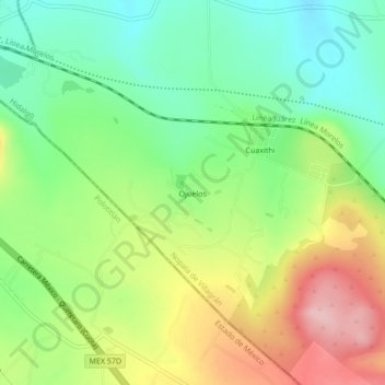
Name: Ojuelos topographic map, elevation, terrain.
Location: Ojuelos, Nopala de Villagrán, Hidalgo, 54237, México (20.19583 -99.79083 20.23583 -99.75083)
Average elevation: 7,713 ft
Minimum elevation: 7,467 ft
Maximum elevation: 8,068 ft
Thank you for supporting this site ❤️
Make a donation
Make a donation
Gear up for your next adventure:
As an Amazon Associate, this site earns from qualifying purchases at no extra cost to you.