
Thank you for supporting this site ❤️
Make a donation
Make a donation
Gear up for your next adventure:
As an Amazon Associate, this site earns from qualifying purchases at no extra cost to you.
Salgueiro topographic map
Click on the map to display elevation.
Thank you for supporting this site ❤️
Make a donation
Make a donation
Gear up for your next adventure:
As an Amazon Associate, this site earns from qualifying purchases at no extra cost to you.
About this map
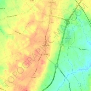
Name: Salgueiro topographic map, elevation, terrain.
Location: Salgueiro, Sosa, Vagos, Aveiro, 3810-265, Portugal (40.54113 -8.64452 40.58113 -8.60452)
Average elevation: 154 ft
Minimum elevation: 46 ft
Maximum elevation: 236 ft
Thank you for supporting this site ❤️
Make a donation
Make a donation
Gear up for your next adventure:
As an Amazon Associate, this site earns from qualifying purchases at no extra cost to you.