Geolocate

Diwa topographic map

Click on the map to display elevation.

About this map

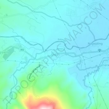
Name: Diwa topographic map, elevation, terrain.

Location: Diwa, Pilar, Bataan, Central Luzon, 2101, Philippines (14.61314 120.49092 14.65314 120.53092)

Average elevation: 203 ft

Minimum elevation: 30 ft

Maximum elevation: 1,240 ft

Gear up for your next adventure:

🧤Hiking Gloves - Protective gloves for rugged trails
🕶️Glacier Sunglasses - Side shields to protect eyes from high-altitude snow glare
🔭Stargazing Telescopes - Perfect for camping in low-light pollution areas shown on maps
🦶Carbon Trekking Poles - Reduce knee impact on steep descents with ultra-light poles
🛏️Cold Weather Sleeping Bag - Warm sleeping bag for cold conditions

As an Amazon Associate, this site earns from qualifying purchases at no extra cost to you.