
Make a donation
Gear up for your next adventure:
As an Amazon Associate, this site earns from qualifying purchases at no extra cost to you.
Rumigny topographic map
Click on the map to display elevation.
Make a donation
Gear up for your next adventure:
As an Amazon Associate, this site earns from qualifying purchases at no extra cost to you.
Rumigny
Rummen est située à 29 m d'altitude. Les villes voisines sont Léau (Zoutleeuw en néerlandais) et Herck-la-Ville (Herk-de-Stad, anciennement Woest-Herk ou Wuest-Herck en néerlandais).
Make a donation
Gear up for your next adventure:
As an Amazon Associate, this site earns from qualifying purchases at no extra cost to you.
About this map
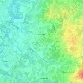
Name: Rumigny topographic map, elevation, terrain.
Location: Rumigny, Geetbets, Louvain, Brabant flamand, Flandre, Belgique (50.85789 5.12841 50.91402 5.18803)
Average elevation: 115 ft
Minimum elevation: 59 ft
Maximum elevation: 256 ft
Make a donation
Gear up for your next adventure:
As an Amazon Associate, this site earns from qualifying purchases at no extra cost to you.
Other topographic maps
Click on a map to view its topography, its elevation and its terrain.
Moorsel
Belgique > Brabant flamand > Louvain > Tervuren
Ce village, entouré de Vossem, Sterrebeek, Kortenberg, Leefdaal et Tervuren, est situé sur le plateau brabançon ondoyant entre 85 et 90 m d'altitude. Ce hameau résidentiel combine à la fois un caractère rural et périurbain ce qui se caractérise par une alternance de champs, de villas et de vieilles…
Average elevation: 246 ft
Make a donation
Gear up for your next adventure:
As an Amazon Associate, this site earns from qualifying purchases at no extra cost to you.