
Make a donation
Gear up for your next adventure:
As an Amazon Associate, this site earns from qualifying purchases at no extra cost to you.
Rouiba topographic map
Click on the map to display elevation.
Make a donation
Gear up for your next adventure:
As an Amazon Associate, this site earns from qualifying purchases at no extra cost to you.
Rouiba
The municipality of Rouiba is entirely within the Plain of Mitidja. It borders neither the sea, nor the Atlas. The altitudes are all very low, of the order of 20 m, and even less than 10 m near the El Biar River which limits the town to the east. Everything is flat, with the small exception of Haraoua ride in the far north, which reaches 50 m. In the Western part, the tight meanders of El Hamiz River emphasize the low slope of the river and flood risk, at least before the construction of the dam opened on the mountain in 1883 which has regularized the flow.
Make a donation
Gear up for your next adventure:
As an Amazon Associate, this site earns from qualifying purchases at no extra cost to you.
About this map
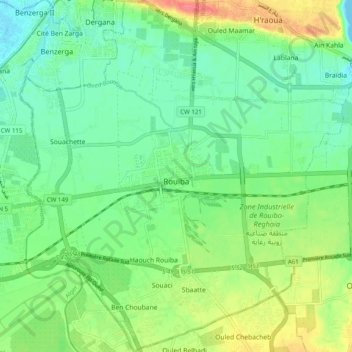
Name: Rouiba topographic map, elevation, terrain.
Location: Rouiba, Rouiba District, Algiers, Algeria (36.69786 3.23863 36.77722 3.32971)
Average elevation: 69 ft
Minimum elevation: -10 ft
Maximum elevation: 200 ft
Make a donation
Gear up for your next adventure:
As an Amazon Associate, this site earns from qualifying purchases at no extra cost to you.
Other topographic maps
Click on a map to view its topography, its elevation and its terrain.