Geolocate

Carter topographic map

Click on the map to display elevation.

About this map

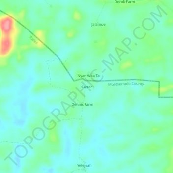
Name: Carter topographic map, elevation, terrain.

Location: Carter, Todee, Montserrado County, Liberia (6.75426 -10.47166 6.79426 -10.43166)

Average elevation: 440 ft

Minimum elevation: 364 ft

Maximum elevation: 682 ft

Gear up for your next adventure:

👓Polarized Sunglasses - Outdoor sunglasses for glare reduction
😴Insulated Sleeping Pads - Compact and warm pads for high-elevation camping
🌧️Backpack Rain Cover - Keep gear dry in wet weather
🥘Titanium Cookware - Durable, featherlight pots and pans for backpacking
🪶Wildlife Field Guides - Learn animal tracking and species ID

As an Amazon Associate, this site earns from qualifying purchases at no extra cost to you.