Geolocate

Pekin topographic map

Click on the map to display elevation.

About this map

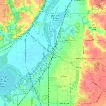
Name: Pekin topographic map, elevation, terrain.

Location: Pekin, Tazewell County, Illinois, 61554, United States (40.53093 -89.67541 40.61909 -89.57456)

Average elevation: 518 ft

Minimum elevation: 430 ft

Maximum elevation: 663 ft

Tazewell County trails, hiking, mountain biking, running and outdoor activities

Other topographic maps

Click on a map to view its topography, its elevation and its terrain.

Allentown

United States > Illinois > Tazewell County

Average elevation: 673 ft

Groveland

United States > Illinois > Tazewell County

Average elevation: 745 ft

Brock Lake

United States > Illinois > Tazewell County > Mackinaw

Average elevation: 617 ft

Gear up for your next adventure:

🧭Compass with Lanyard - Easy‑carry compass for navigation
👟Trail Running Shoes - Lightweight shoes for trail runners
📱Heavy-Duty Phone Cases - Drop-proof and waterproof protection for outdoor navigation
🧥Men's Rain Shells - Premium waterproof and breathable jackets for mountain weather
🪄Magnetic Compass - Accurate compass for navigation

As an Amazon Associate, this site earns from qualifying purchases at no extra cost to you.