Geolocate

Costa topographic map

Click on the map to display elevation.

About this map

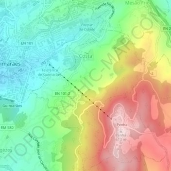
Name: Costa topographic map, elevation, terrain.

Location: Costa, Guimarães, Braga, Portugal (41.42272 -8.28950 41.45301 -8.25778)

Average elevation: 1,122 ft

Minimum elevation: 551 ft

Maximum elevation: 1,972 ft

Other topographic maps

Click on a map to view its topography, its elevation and its terrain.

Guimarães

Portugal > Braga > Guimarães

Average elevation: 981 ft

Além

Portugal > Braga > Guimarães > Sande (Vila Nova)

Average elevation: 472 ft

Gear up for your next adventure:

💧Water Filtration Bottles - Safely drink from streams and lakes while exploring
📦Gear Storage Bags - Organize and protect outdoor equipment
👟Trail Running Shoes - Lightweight shoes for trail runners
🛌Ultralight Sleeping Bags - Compact down bags for cold nights in the wilderness
🌧️Backpack Rain Cover - Keep gear dry in wet weather

As an Amazon Associate, this site earns from qualifying purchases at no extra cost to you.