
Town of Day topographic map
Interactive map
Click on the map to display elevation.
About this map
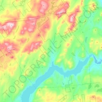
Name: Town of Day topographic map, elevation, terrain.
Location: Town of Day, Saratoga County, New York, 12835, United States (43.26298 -74.16011 43.38727 -73.92637)
Average elevation: 1,463 ft
Minimum elevation: 696 ft
Maximum elevation: 2,753 ft
Saratoga County trails, hiking, mountain biking, running and outdoor activities
Other topographic maps
Click on a map to view its topography, its elevation and its terrain.
Woodcock Mountain
United States > New York > Saratoga County > Town of Hadley
Average elevation: 889 ft
Ballston Lake
United States > New York > Saratoga County > Town of Clifton Park
Average elevation: 351 ft
Mechanicville
United States > New York > Saratoga County > City of Mechanicville > Mechanicville
Average elevation: 203 ft