
Küsnacht (ZH) topographic map
Interactive map
Click on the map to display elevation.
About this map
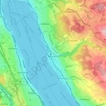
Name: Küsnacht (ZH) topographic map, elevation, terrain.
Location: Küsnacht (ZH), Bezirk Meilen, Zurich, 8700, Switzerland (47.30331 8.56024 47.33586 8.65858)
Average elevation: 1,660 ft
Minimum elevation: 1,312 ft
Maximum elevation: 2,431 ft
Other topographic maps
Click on a map to view its topography, its elevation and its terrain.
Zumikon
Switzerland > Zurich > Bezirk Meilen
Zumikon, Bezirk Meilen, Zurich, 8126, Switzerland
Average elevation: 2,126 ft
Lake Zurich
Switzerland > Zurich > Bezirk Meilen
Lake Zurich, Bezirk Meilen, Zurich, Switzerland
Average elevation: 1,814 ft
Hasenacker
Switzerland > Zurich > Bezirk Meilen > Männedorf
Hasenacker, Männedorf, Bezirk Meilen, Zurich, 8708, Switzerland
Average elevation: 1,588 ft