Geolocate

Gale topographic map

Click on the map to display elevation.

About this map

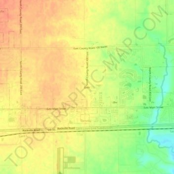
Name: Gale topographic map, elevation, terrain.

Location: Gale, Hendricks County, Indiana, 46122, United States (39.74671 -86.48666 39.78671 -86.44666)

Average elevation: 883 ft

Minimum elevation: 787 ft

Maximum elevation: 938 ft

Hendricks County trails, hiking, mountain biking, running and outdoor activities

Other topographic maps

Click on a map to view its topography, its elevation and its terrain.

North Salem

United States > Indiana > Hendricks County

Average elevation: 912 ft

Stilesville

United States > Indiana > Hendricks County

Average elevation: 787 ft

Coatesville

United States > Indiana > Hendricks County

Average elevation: 889 ft

Pittsboro

United States > Indiana > Hendricks County

Average elevation: 935 ft

Amo

United States > Indiana > Hendricks County

Average elevation: 837 ft

Avon

United States > Indiana > Hendricks County

Average elevation: 833 ft

Danville

United States > Indiana > Hendricks County

Average elevation: 922 ft

Clayton

United States > Indiana > Hendricks County

Average elevation: 863 ft

Lizton

United States > Indiana > Hendricks County

Average elevation: 958 ft

Gear up for your next adventure:

📷Action Cameras - Rugged cameras to document your journeys across rugged terrain
🧭Outdoor Navigation Book - Learn advanced navigation skills
🧦Merino Wool Socks - Moisture-wicking, blister-preventing socks for long treks
🛰️Satellite Messengers - Emergency SOS and two-way messaging for off-grid adventures
🧢Sun Protection Hats - Wide-brimmed and UPF-rated hats for high-altitude sun safety

As an Amazon Associate, this site earns from qualifying purchases at no extra cost to you.