Geolocate

Munson Township topographic map

Click on the map to display elevation.

About this map

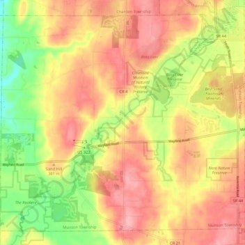
Name: Munson Township topographic map, elevation, terrain.

Location: Munson Township, Geauga County, Ohio, United States (41.49971 -81.29711 41.57038 -81.19051)

Average elevation: 1,201 ft

Minimum elevation: 961 ft

Maximum elevation: 1,378 ft

Geauga County trails, hiking, mountain biking, running and outdoor activities

Other topographic maps

Click on a map to view its topography, its elevation and its terrain.

Lake Aquilla

United States > Ohio > Geauga County

Average elevation: 1,207 ft

Novelty

United States > Ohio > Geauga County

Average elevation: 1,106 ft

Montville

United States > Ohio > Geauga County

A post office called Montville has been in operation since 1825. The area of Montville was named for its lofty elevation.

Average elevation: 1,214 ft

Newbury

United States > Ohio > Geauga County

Average elevation: 1,204 ft

Welshfield

United States > Ohio > Geauga County > Troy Township

Average elevation: 1,155 ft

Little Mountain

United States > Ohio > Geauga County

Average elevation: 1,073 ft

Chester Center

United States > Ohio > Geauga County > Chester Center

Average elevation: 1,178 ft

Eldon Russel Park

United States > Ohio > Geauga County

Average elevation: 1,115 ft

Gear up for your next adventure:

🔭Compact Binoculars - HD vision for scouting terrain and identifying distant landmarks
🪶Survival Guide Book - Expert advice for emergency preparedness
🗺️Topographic Maps - Detailed topo maps for hiking, exploring and outdoor navigation
📱Heavy-Duty Phone Cases - Drop-proof and waterproof protection for outdoor navigation
🪓Survival Multi‑Tool - Versatile tool for camp and trail tasks

As an Amazon Associate, this site earns from qualifying purchases at no extra cost to you.