
Country Hills topographic map
Click on the map to display elevation.
About this map
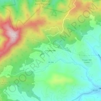
Name: Country Hills topographic map, elevation, terrain.
Location: Country Hills, Roanoke County, Virginia, United States (37.19541 -80.11615 37.23541 -80.07615)
Average elevation: 1,926 ft
Minimum elevation: 1,309 ft
Maximum elevation: 3,048 ft
Roanoke County trails, hiking, mountain biking, running and outdoor activities
Other topographic maps
Click on a map to view its topography, its elevation and its terrain.
Vinton
United States > Virginia > Roanoke County
Vinton has varied topography, considering its 3.2 square mile size. The above-mentioned lake is at an elevation of 890 feet (270 m) above sea level. The Vinton side of the lake consists of a steep, wooded cliff 150 feet (46 m) in vertical height. Vinton's highest point is on Olney Road, at an elevation of…
Average elevation: 1,001 ft