Geolocate

Rouen topographic map

Click on the map to display elevation.

About this map

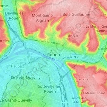
Name: Rouen topographic map, elevation, terrain.

Location: Rouen, Seine-Maritime, Normandy, Metropolitan France, France (49.41720 1.03006 49.46526 1.15212)

Average elevation: 236 ft

Minimum elevation: -10 ft

Maximum elevation: 561 ft

Other topographic maps

Click on a map to view its topography, its elevation and its terrain.

Le Pollet

France > Normandy > Seine-Maritime > Torcy-le-Petit

Average elevation: 276 ft

Le Pière

France > Normandy > Seine-Maritime > Étaimpuis

Average elevation: 515 ft

La Fresnaye

France > Normandy > Seine-Maritime > Buchy

Average elevation: 659 ft

La Grand Route

France > Normandy > Seine-Maritime > Écalles-Alix

Average elevation: 482 ft

Edreville

France > Normandy > Seine-Maritime > Octeville-sur-Mer

Average elevation: 256 ft

Rouen

France > Normandy > Seine-Maritime > Rouen

Average elevation: 338 ft

Gear up for your next adventure:

🧷Carabiner Set - Durable clips for gear attachment
🚪Portable Camp Chair - Foldable chair for comfort at camp
📱Solar Portable Charger - Solar power bank for charging devices off‑grid
🩳Quick‑Dry Hiking Shorts - Comfortable and quick‑dry shorts for summer hiking
📻Weather Alert Radios - Stay informed of storm risks while off-the-grid

As an Amazon Associate, this site earns from qualifying purchases at no extra cost to you.