
Make a donation
Gear up for your next adventure:
As an Amazon Associate, this site earns from qualifying purchases at no extra cost to you.
Harapanahalli topographic map
Click on the map to display elevation.
Make a donation
Gear up for your next adventure:
As an Amazon Associate, this site earns from qualifying purchases at no extra cost to you.
Harapanahalli
It has an average elevation of 633 metres (2076 feet) away from the sea level. Harapanahalli is surrounded by several districts like Davanagere in the South, Chithradurga in the Southeast, Haveri in the West. Harapanahalli had operated under Bellari, Davanagere districts and Now it is operating under Vijayanagara District.
Make a donation
Gear up for your next adventure:
As an Amazon Associate, this site earns from qualifying purchases at no extra cost to you.
About this map
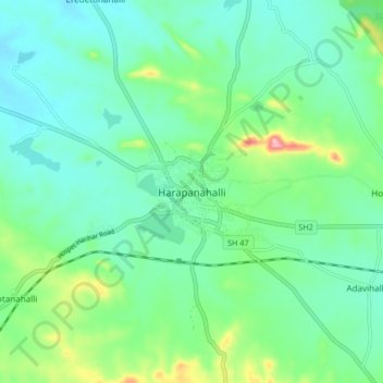
Name: Harapanahalli topographic map, elevation, terrain.
Average elevation: 2,054 ft
Minimum elevation: 1,916 ft
Maximum elevation: 2,484 ft
Make a donation
Gear up for your next adventure:
As an Amazon Associate, this site earns from qualifying purchases at no extra cost to you.