
Birgitz topographic map
Interactive map
Click on the map to display elevation.
About this map
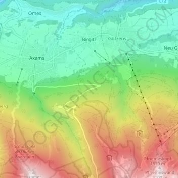
Name: Birgitz topographic map, elevation, terrain.
Location: Birgitz, Bezirk Innsbruck-Land, Tyrol, 6092, Autriche (47.19861 11.28572 47.24621 11.31694)
Average elevation: 3,963 ft
Minimum elevation: 2,182 ft
Maximum elevation: 6,919 ft
Other topographic maps
Click on a map to view its topography, its elevation and its terrain.
Schmirn
Autriche > Tyrol > Bezirk Innsbruck-Land > Gemeinde Schmirn
Schmirn, Gemeinde Schmirn, Bezirk Innsbruck-Land, Tyrol, 6154, Autriche
Average elevation: 6,201 ft
Ladins
Autriche > Tyrol > Bezirk Innsbruck-Land > Schmirn
Ladins, Schmirn, Bezirk Innsbruck-Land, Tyrol, Autriche
Average elevation: 6,473 ft
Obern
Autriche > Tyrol > Bezirk Innsbruck-Land > Gemeinde Leutasch
Obern, Gemeinde Leutasch, Bezirk Innsbruck-Land, Tyrol, 6105, Autriche
Average elevation: 4,364 ft
Gemeinde Seefeld in Tirol
Autriche > Tyrol > Bezirk Innsbruck-Land
Gemeinde Seefeld in Tirol, Bezirk Innsbruck-Land, Tyrol, 6100, Autriche
Average elevation: 4,275 ft
Gemeinde Gnadenwald
Autriche > Tyrol > Bezirk Innsbruck-Land
Gemeinde Gnadenwald, Bezirk Innsbruck-Land, Tyrol, 6069, Autriche
Average elevation: 4,190 ft
Gemeinde Schmirn
Autriche > Tyrol > Bezirk Innsbruck-Land
Gemeinde Schmirn, Bezirk Innsbruck-Land, Tyrol, 6154, Autriche
Average elevation: 6,260 ft
Leutasch
Autriche > Tyrol > Bezirk Innsbruck-Land
Leutasch, Bezirk Innsbruck-Land, Tyrol, 6105, Autriche
Average elevation: 4,793 ft