
Thank you for supporting this site ❤️
Make a donation
Make a donation
Gear up for your next adventure:
As an Amazon Associate, this site earns from qualifying purchases at no extra cost to you.
Sai Osru topographic map
Click on the map to display elevation.
Thank you for supporting this site ❤️
Make a donation
Make a donation
Gear up for your next adventure:
As an Amazon Associate, this site earns from qualifying purchases at no extra cost to you.
About this map
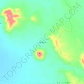
Name: Sai Osru topographic map, elevation, terrain.
Location: Sai Osru, Kutum, North Darfur State, Sudan (14.52857 24.27727 14.56857 24.31727)
Average elevation: 3,445 ft
Minimum elevation: 3,287 ft
Maximum elevation: 3,898 ft
Thank you for supporting this site ❤️
Make a donation
Make a donation
Gear up for your next adventure:
As an Amazon Associate, this site earns from qualifying purchases at no extra cost to you.