
Hochvernagtspitze topographic map
Interactive map
Click on the map to display elevation.
About this map
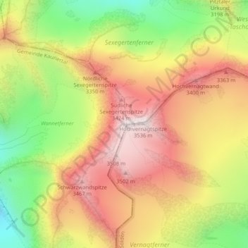
Name: Hochvernagtspitze topographic map, elevation, terrain.
Location: Hochvernagtspitze, Kaunertal, Landeck, Tirol, Österreich (46.88122 10.79389 46.88132 10.79399)
Average elevation: 10,213 ft
Minimum elevation: 8,701 ft
Maximum elevation: 11,503 ft
Other topographic maps
Click on a map to view its topography, its elevation and its terrain.
Hintereisferner
Österreich > Tirol > Kaunertal
Hintereisferner, 902 Doloretteweg, Kaunertal, Imst, Tirol, 6458, Österreich
Average elevation: 9,764 ft