
Make a donation
Gear up for your next adventure:
As an Amazon Associate, this site earns from qualifying purchases at no extra cost to you.
Khuzdar topographic map
Click on the map to display elevation.
Make a donation
Gear up for your next adventure:
As an Amazon Associate, this site earns from qualifying purchases at no extra cost to you.
Khuzdar
Khuzdar is at the apex of a narrow valley at an elevation of 1,237 metres (4,058 ft). Despite this altitude, Khuzdar like most of Balochistan has an arid climate (Köppen BWh) with very low and erratic rainfall. Unlike most parts of the province, the heaviest average rainfall comes from the Asian monsoon in July and August, though this rainfall tends to be very erratic and in many summers there is no significant rain at all.
Make a donation
Gear up for your next adventure:
As an Amazon Associate, this site earns from qualifying purchases at no extra cost to you.
About this map
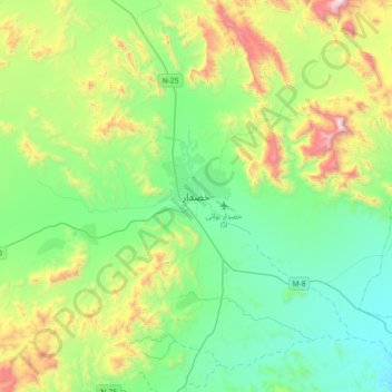
Name: Khuzdar topographic map, elevation, terrain.
Average elevation: 4,649 ft
Minimum elevation: 3,389 ft
Maximum elevation: 7,999 ft
Make a donation
Gear up for your next adventure:
As an Amazon Associate, this site earns from qualifying purchases at no extra cost to you.
Other topographic maps
Click on a map to view its topography, its elevation and its terrain.