
Thank you for supporting this site ❤️
Make a donation
Make a donation
Gear up for your next adventure:
As an Amazon Associate, this site earns from qualifying purchases at no extra cost to you.
Talavadi topographic map
Click on the map to display elevation.
Thank you for supporting this site ❤️
Make a donation
Make a donation
Gear up for your next adventure:
As an Amazon Associate, this site earns from qualifying purchases at no extra cost to you.
About this map
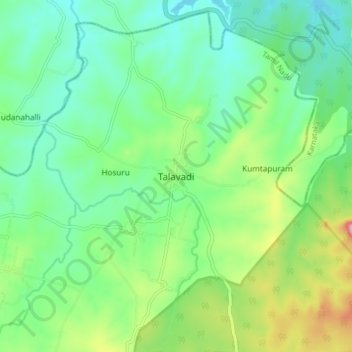
Name: Talavadi topographic map, elevation, terrain.
Location: Talavadi, Thalavadi, Erode District, Tamil Nadu, 638461, India (11.73713 76.96533 11.81713 77.04533)
Average elevation: 2,621 ft
Minimum elevation: 2,428 ft
Maximum elevation: 3,094 ft
Thank you for supporting this site ❤️
Make a donation
Make a donation
Gear up for your next adventure:
As an Amazon Associate, this site earns from qualifying purchases at no extra cost to you.