Geolocate

Gabes Medina topographic map

Interactive map

Click on the map to display elevation.

About this map

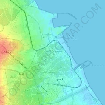
Name: Gabes Medina topographic map, elevation, terrain.

Location: Gabes Medina, Gabès, Tunisie (33.87178 10.07260 33.93587 10.12496)

Average elevation: 33 ft

Minimum elevation: -13 ft

Maximum elevation: 151 ft

Other topographic maps

Click on a map to view its topography, its elevation and its terrain.

Oudref

Tunisie > Gabès > Oudref

Oudref, Ouedhref Sud, El Metouia, Gabès, 6052, Tunisie

Average elevation: 112 ft

Gabès

Tunisie > Gabès > Gabès

Gabès, Secteur (3), Gabes Medina, Gabès, 6001, Tunisie

Average elevation: 118 ft

El Hamma

Tunisie > Gabès

El Hamma, Gabès, 6062, Tunisie

Average elevation: 394 ft

Nouvelle Matmata

Tunisie > Gabès

Nouvelle Matmata, Gabès, Tunisie

Average elevation: 650 ft

Matmata

Tunisie > Gabès

Matmata, Gabès, 6070, Tunisie

Average elevation: 863 ft

El Metouia

Tunisie > Gabès

El Metouia, Gabès, 6052, Tunisie

Average elevation: 121 ft

El Behaier

Tunisie > Gabès

El Behaier, El Hamma, Gabès, 6062, Tunisie

Average elevation: 328 ft

Menzel El Habib

Tunisie > Gabès

Menzel El Habib, Gabès, 6030, Tunisie

Average elevation: 335 ft