
Make a donation
Gear up for your next adventure:
As an Amazon Associate, this site earns from qualifying purchases at no extra cost to you.
Hunnewell topographic map
Click on the map to display elevation.
Make a donation
Gear up for your next adventure:
As an Amazon Associate, this site earns from qualifying purchases at no extra cost to you.
About this map
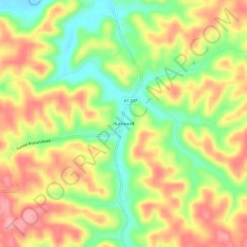
Name: Hunnewell topographic map, elevation, terrain.
Location: Hunnewell, Greenup County, Kentucky, 41122, United States (38.39341 -82.86544 38.43341 -82.82544)
Average elevation: 725 ft
Minimum elevation: 538 ft
Maximum elevation: 892 ft
Greenup County trails, hiking, mountain biking, running and outdoor activities
Make a donation
Gear up for your next adventure:
As an Amazon Associate, this site earns from qualifying purchases at no extra cost to you.
Other topographic maps
Click on a map to view its topography, its elevation and its terrain.
Flatwoods
United States > Kentucky > Greenup County
The area now known as Flatwoods was originally named "Advance": Advance Methodist Church formed a Sunday school beginning in 1860. The name was later changed to "Cheap", after John Cheap, a blind clergyman. The original farming community returned to the name of "Advance" when a post office was established in…
Average elevation: 636 ft
Make a donation
Gear up for your next adventure:
As an Amazon Associate, this site earns from qualifying purchases at no extra cost to you.
Bellefonte
United States > Kentucky > Greenup County
The city is located on a one-mile wide belt of relatively flat land that is approximately 100 feet higher in elevation than the nearby Ohio River valley. The unusual topography which is easily noticeable on topographical maps and aerial satellite imagery was created by the ancient Teays River. Larger than the…
Average elevation: 617 ft